So, you've got your new drone. It's set up, you've done all the firmware updates, and you're ready to fly. But where do you fly, and when? You don't want to stray into closed airspace, and you certainly don't want your drone to be blown into the next available tree, or drowned in some torrential rain. And you absolutely want to avoid flying your drone into the engine or cockpit of a manned aircraft. Thankfully, you don't need to be superhuman to manage all of that. There's a ton of resources out there, both for neophyte drone pilots and for the more seasoned remote aviators, from web pages (like my weather blog for example ;) ), to a plethora of apps. There's literally more stuff out there than you can shake a stick at, but personally, I only use a handful at this stage.

Weather
Pretty much all consumer drones these days are fair-weather UAVs, no matter how you twist or turn it. Some drones can take more punishment than others, but in effect, once the weather turns bad, all stay on the ground. Therefore, it is vital to know exactly what Mother Nature is going to throw at you before setting off.
UAV Forecast


UAV Forecast does exactly what it says on the tin. It provides a detailed breakdown of current weather conditions, as well as a detailed hourly forecast, information about winds both at ground level and at altitude. It even provides information about geomagnetic storms that could potentially interfere with the communication between you and your drone, or an overview of the available GPS satellites. Any of those parameters is displayed in a simple colour scheme that allows you to assess the conditions at a glance. Green means you're okay to fly, Yellow means that conditions are still okay, but pushing the envelope, while Red simply means: Leave the drone on the ground. At first glance, the interface might seem simple, even a bit old school, but don't let that fool you. Not only is the overview superbly detailed, you can actually adapt the thresholds for the different conditions in the settings, depending on the power and weight of your drone. I mean, naturally, a Mavic Pro can take more of a beating than my Spark can. It also provides an airspace map, displaying any no-fly-zones or restricted areas in your vicinity. There's also an In-App purchase available that'll give you full access to even more detailed, and more precisely longer term forecasts, but for checking the weather the day before flying, the free version is more than enough.
Hover


Just like UAV Forecast, Hover primarily focusses on providing weather forecasts for drone pilots. However, Hover sticks to a more traditional display style, looking more like your run-of-the-mill weather app. If it does altitude wind forecasts, I haven't found it yet, and in general, it is a bit more of a "consumer" app. That's not to say it can't be useful. It has a flight log option that I haven't tried yet, and, like UAV forecast, also has an airspace map integrated. What's more, it has a drone specific newsfeed reader integrated, which is a nice touch. All in all, it comes down to a simple question of personal preference.
Airspace
If you read the news these days, the majority of drone accident headlines seem to be dealing with some kind of airspace violation or conflict. I personally believe that many drone regulations, like those issued by the IAA here in Ireland, are a bit on the strict side, although I understand the reasoning behind putting such regulations in place. We can't just go flying wherever we want when an airport, a military installation, or a prison is nearby, and a drone isn't just a harmless toy. When one of those things hits an aircraft engine or cockpit windscreen, significant damage is all but guaranteed, so it is vital for every drone pilot to know where he is, know what airspace he is operating in, and what, if any, aircraft are nearby.
AirMap

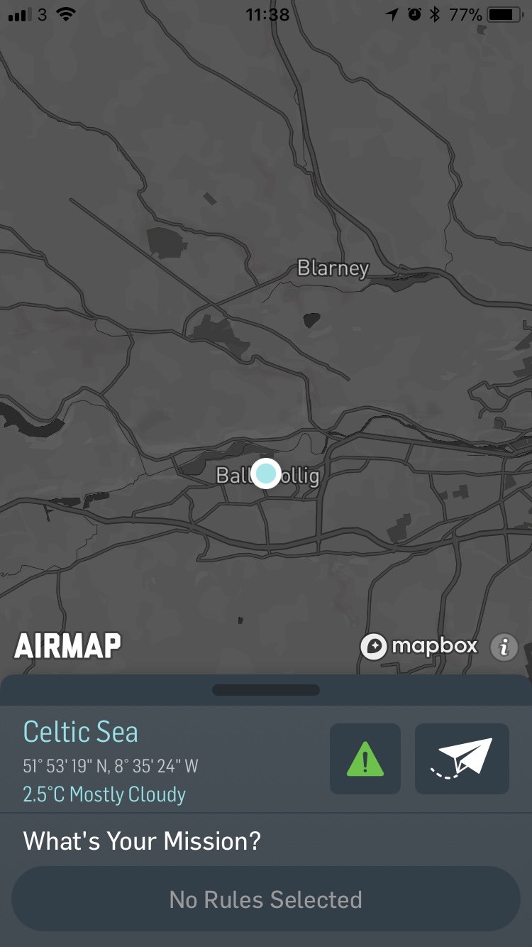
Oh boy, where do I start? AirMap is a very powerful tool hiding behind a deceptively simple interface. At its heart is the airspace map. In fact, AirMap is the map source used by both UAV Forecast and Hover. Once again, it shows an overview of the airspace around you, and any restricted areas are highlighted. However, when you swipe up, a panel appears pointing out any rules or advisories you should, or have to, adhere to when flying. In addition, there's an option to forward your ID and position to the nearest air traffic control tower to let them know you're operating in the vicinity. There's also a flight planning option included in there. Both of the latter options are aimed at professional pilots, and require registration. Also, I'm not sure if the notification option works outside of the US quite yet.
All in all, I'm quite conflicted about AirMap. Granted, it is a very valuable resource, but if you're a DJI jockey, you likely won't need most of it, as DJI Go 4 already includes an airspace map and notifications on airspace restrictions. However, if your drone control app doesn't include this functionality, then by all means, go for it.

Flightradar24.com


Okay, so this is pushing the boundary a bit. However, there's no denying that, barring lugging a fully blown ADS-B receiver around with you, this handy app is the best option when it comes to knowing what aircraft are operating in your vicinity. Basically, flightradar24.com uses the transponder signals sent out by civilian aircraft to display their position and other data on a Google Maps like interface. The app uses the location data provided by your phone to center the map on your position, showing you exactly what is going on in your area. It's as simple as that. There are several levels of in-app purchases available, and I myself am a paying customer, however, there's also a free tier.
There are some drawbacks, although they can't really be attributed to flightradar24 itself. A number of aircraft don't always use their transponders, or at least their ADS-B transponders. This is particularly the case for law-enforcement or military aircraft, so the app will not alert you if the Irish Air Corps sends their entire helicopter fleet, all seven of them, to conduct an airborne landing drill in your vicinity. So always keep your eyes and ears open, or take a spotter with you.
NOTAMS
Okay, here I'm really pushing the boundaries, since this isn't an app. However, NOTAMs, or Notices to Airmen, are absolutely vital as far as I'm concerned. These notices are bulletins that are regularly issued by the aviation authorities of their respective countries. In Ireland, that would be the IAA. These bulletins contain all kinds of information, most of which isn't really relevant to drone operators, such as Instrument Landing Systems (ILS) being down at a certain airport due to repair, or taxiway closures at an airport due to ongoing construction work. However, they also contain information about temporary airspace closures, for example when the Air Corps or Irish Navy are holding live fire drills. These closures will also often take place over high profile events, but can have all kinds of reasons. In many cases, AirMap or other similar providers should be quick enough to include that in their apps, however it can never hurt to head over to the IAA website, and check the latest NOTAM a day or two before you plan to go drone flying.
With all that being said, there's one more thing I cannot stress enough: None of these apps absolve you as a drone pilot of your personal responsibility. It is YOUR job to familiarise yourself with the legislation in your particular area, and with the peculiarities of your particular drone. No matter how much effort you put into planning for every eventuality, there will always be one thing you didn't take into consideration, so be ready for it. Fly in a way that leaves drone pilots in a positive light, and if you do go beyond legal limits, which is your choice, at least speak up, and own up if something goes wrong.
Comments
Post a Comment