"Everything in life is somewhere else, and you get there in a car." E.B White has nailed the transport philosophy that has been prevalent throughout most of the western world in the 20th century. The car has traditionally been seen as the ultimate tool in ensuring mobility in our society. It is seen as a symbol of freedom, of social status, and used as a tool to exert authority, whether real or imagined. However, the enormous success of cars has lead to a situation where, over the last two decades of the 20th century, and indeed for the entire first 16 years of the 21st century, infrastructure, especially in large urban centres, has simply been unable to cope with the amount of traffic, with predictable results. Cities have ground to a standstill, and city life has been choked by exhaust gases and noise.
Cork, the city that I’ve been calling home since 2012, is a prime example for this, as it indeed is an example for possible solutions and potential pitfalls. So, for the rest of this potentially very long article, I’ll spell out my thoughts on this rather expansive issue. Just a word of advice, though. While I will do my best to quote official sources on some of the issues at hand, I’m very much writing this from a user perspective. So, if you’re looking for lofty theoretical discussions, allow me to redirect you to the nearest university, where you’ll no doubt find an abundance of professors with impressive academic credentials and questionable real-life experience.
 |
| Believe me, there is method to this madness! |
So, lets get right into it. Cork, despite all the things I love about it, is a flawed city traffic-wise. Almost all of the original historic city centre is still intact, and given that much of said city centre developed between the 17th and 19th century, that means narrow streets, with side streets branching off much too often to ensure a smooth flow of traffic. Many locals are also either unaware of the meaning of traffic lights, or simply ignore them altogether, running lights and jaywalking are an everyday occurrence. That in itself would not be such a big issue, however, the terrain on which Cork was built, especially on the north side of the city makes the “two ring road” system that is often used in similar cities on the continent all but impossible.
Add to that the myriads of cookie-cutter suburbs that have sprung up all around the city centre since the 1950s, all of them without being connected to the city by an effective system of main and branch roads, and you have a traffic nightmare for drivers, indeed for all road users. Damn, that’s a lot of commas in one sentence! Tailbacks are common, especially during rush hour. Try getting to the Apple campus in Hollyhill, or any of the edge of town business parks between 7.30 and 9.30 AM, or anywhere within Cork, and you’ll see what I mean. The city is simply not built for this kind of traffic. However, due to a totally misguided transport infrastructure policy dating pretty much to the foundation of the modern state of Ireland, many people simply have no choice but to drive, as public traffic is limited both in scope an reliability, which is something I’ll touch on later in this article. All this combines into a toxic brew that makes it very difficult to enjoy the city. street side cafes in Cork? Not the best idea, even when the Irish weather cooperates, which is not all that often. Shopping, outside pedestrianised zones like Opera Lane, the Huguenot Quarter or Oliver Plunkett Street, is also more often than not a chore due to the high amount of traffic in the city centre.
Lots of problems, so, for Cork to solve. And that is only for individual motorists, there are numerous other problem areas. I’ll outline the biggest of them over the next few paragraphs.
Cycling
 |
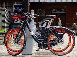
| Coca Cola Zero Bikes. You just can't escape it on my blog ;) |
Okay, it may sound mean to mention cycling here, given the massive progress in this area of the last few years, still, all is not well in the rebel state of Cork. Cycling is of course an ideal way for short commutes, not to mention a much cheaper alternative than all other forms of transport, except walking. This is especially true for those living in the city centre. So, promoting cycling should be a top priority for any city council, and Cork City Council has made great strides in that direction over the last years. All over the city, roads have been redesigned to accommodate bike lanes, public places have been equipped with bike racks, etc.. And then, there’s Coca Cola Zero Bikes. Yep, there it is again, and for good reason. The system has done more than any of the other measures I just mentioned to promote cycling within the city. It’s dirt cheap, reliable, and you have all the advantages of having a bike, while avoiding the hassle of maintenance, or storage. The numbers, published by Transport for Ireland on February 16th, speak for themselves. 290,066 journeys have been made with Coke Zero Bikes in Cork since the system started partial operations on December 18th, 2014, with the 7416 subscribers in the city covering a total distance of 454,560 kilometres. That makes it not only the largest, but also by far the most popular bike-sharing system outside Dublin, even surpassing the system in Belfast.
 |
| The availability of bikes at crucial points in the city, like here on Grand Parade, has really transformed Cork. |
 |
| Both full-blown bi-directional cycleways, like this one on Parnell Place... |
 |
| ... and counterflow lanes like here on South Main Street really make cycling not only more convenient, but safer. |
But, as I said, not all is well within the rebel city. The bike lanes are great, no doubt about that. When you have one available, that is. There are great lanes out there, Parnell Place, Popes Quay, or the Lower Glanmire Road up to Kent Station are prime examples, but they are still just a patchwork and not a real network. There’s no safe segregated way of getting for example from Kent Station to UCC, you’ll have to battle your way along the quays between the end of the Glanmire Road bike lane and the beginning of the bike lane on Washington Street. Staying on the north side of the river isn’t going to help either, as there is a huge gap there as well, between Brian Boru Bridge and the beginning of the Pope Quay Bike Lane.
 |
| Pop quiz: You approach this intersection (South Main Street/Washington Street) on the counterflow bike lane, and want to turn right at that intersection. However the lane delivers you onto the sidewalk. So, what do you do? |
 |
| The Parnell Place-Anglesea Street cycleway is an amazing piece of cycling infrastructure, that much is certain. However, separating a Coke Zero Bikes station from this cycleway by placing it on the other side of a busy three lane road, in this case Anglesea Street, is pretty idiotic, if you excuse the language. |
What’s more, some of the lanes, or rather the way they’re arranged, don’t really make much sense. Take the counterflow bike lane on South Main Street, for example. A nice lane, clearly separated from other traffic, it really helps you get into the city quickly from St. Finbarr’s cathedral or Elizabeth Fort. Until you get to the intersection with Washington Street, that is. The bike lane merges with the sidewalk, leaving cyclists scratching their head about how to continue. Another prime example is the otherwise great bike lane along Parnell Place. A completely separated bike lane, with two direction lanes, it runs all the way along Parnell Place… except for a 30-40 metre stretch right in the middle near the intersections with Oliver Plunkett Street and Maylor Street, where cyclist suddenly find themselves confronted with metal pylons marking the entrances to these roads. Better make up your mind quickly about how to proceed.
 |
| Parnell Place Panorama. Cycleway on the left, cycleway on the right, notice anything missing? |
One big problem however is not, or rather only partially related to the cycling infrastructure in place in city. Most bike lanes are visually very distinct, with their red colour and bike symbols every ten to twenty metres, and arrows indicating the direction of traffic. However, as distinctive as this may be, it still seems to be an enigma to a shockingly large number of people, including cyclists. No matter what cycle lane you’re on, there is a real chance that you’ll encounter a cyclist cycling the wrong way on said lane. Pedestrians stray into the lane, often looking as if you’ve just arrived in a spaceship when you use the bell. And then, there’s the stray parkers! South Main Street is especially bad, you’ll often have 3-4 cars blocking up the bike lane, forcing cyclists to evade into oncoming traffic. I have one very clear message for these individuals: If you don’t know what the direction arrows on the lanes mean, you shouldn’t be on a bike, you shouldn’t even be out in public unsupervised! And if you can’t recognise a bike lane and find another place to park, then don’t take your car into the city! And don’t give me any BS about car parks being too expensive, if you’ve got enough money to keep a car running, you can spare the money for a proper car park!
 |
| GET THAT PILE OF JUNK OFF THE BIKE LANE!!!! I don't care how short that stay is, if you're not part of an emergency service RESPONDING to an emergency, you have no business parking your car on a bike lane. |
Commuter Rail
 |
| 2600 Class commuter train pulling into Little Island station on the Cork Commuter Rail network. |
Much less passive aggression in this next segment, not least because it is really running surprisingly well, even though it is just a shadow of its former self. From the 4 rail termini in Cork during its heyday, only Kent Station remains, the remainder being either repurposed or disappearing altogether. The route network has also shrunk massively, only leaving 3 commuter lines. I’ll leave out the Cork to Mallow service for the time being, as that is currently a hybrid commuter/intercity operation. The two pure commuter lines from Kent Station serve Midleton and Cobh, separating at Glonthaune. The Midleton Line originally went all the way to Youghal in East County Cork, but given the fact that the branch from Glonthaune to Midleton itself was only reopened in 2009, the operation is pretty good. And, to be frank, you really don’t have much option of expanding the network in other directions from Kent station anyway, not without massive tunnelling and bridge building, which would only serve to deliver passengers to a station on the periphery of the city centre.
 |
| This island platform at Cork Kent Station is the heart of Cork's Commuter Rail network. A train to Midleton has arrived on Platform 1, while a service to Cobh is boarding on Platform 2. |
 |
| Not really an unattractive platform roof, if you ask me. |
 |
| 2600 Class DMU about to operate a commuter service to Cobh. |
Services on both lines operate at 30 minute intervals during rush hour, with hourly departures during the rest of the day. Speed restrictions while leaving Kent station slow the service down a bit, but apart from that, there’s no real impediment to increase the frequency on both lines, especially the Cobh line, which is a dual track line all the way to its terminus at Cobh. Operations are done pretty much exclusively with 2600 Class Diesel Multiple Units (DMU) built by Tokyu Car Corporation in Japan. They aren’t the newest trains, being delivered between 1993 and 1994, and their Japanese heritage is obvious to anyone with a cursory interest in railways, but they are good units and still going strong.
 |
| Another shot of a 2600 DMU, this one is just pulling into Cobh, the terminus of this line. |
 |
| Here's another view of the terminus at Cobh. |
Bus Public Transit
 |
| Most of the buses in Cork, like this Volvo double-decker, don't really look too bad, and are pretty modern. The issues are more of a systemic nature. |
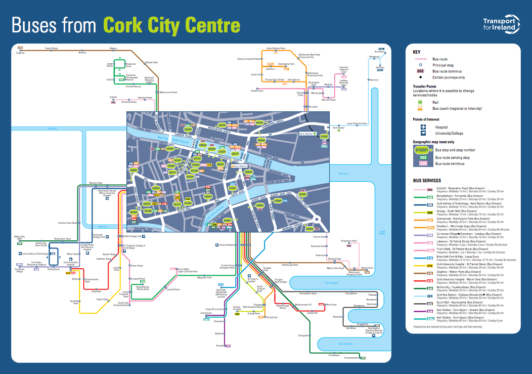
Oh boy, where do I start? Bus transit in Cork is only a few inches short of being a total basket case. Not necessarily due to any fault of the city council. The issue here lies squarely with the way public transport is set up in this country. Bus Éireann, who operates 90% of bus routes outside of Dublin is, like Irish Rail, a complete subsidiary of CIÉ, the Irish national transport holding company, based in Dublin. That also means that all route planning and vehicle allocation is being done from Dublin. This has lead to a situation where a city like Cork sports a nice enough bus network on paper, but one that is pretty much incomprehensible to all but seasoned commuters.

The theory sounds great. 15 bus lines serving all main points of the city, 13 of them going through the city centre, with two lines serving as orbital routes on the periphery. The buses are okay as well, although some, especially the single decker Scania Omni Link buses, have issues with leaking roofs, as if there wasn’t already enough rain outside of the buses. The real devil however is, as always, in the details. First of all, the logic behind the network does not always seem obvious, even though Transport for Ireland has finally managed to produce coherent maps of the major bus networks throughout Ireland.
Second of all, the stops are very hard to find, once you’re outside the city centre and away from the major commuter destinations. In addition, while many lines are operated at pretty decent intervals, the 202 service to Hollyhill that I used to take to work runs at roughly fifteen minute intervals throughout the weekday, only thinning in the early morning and “late” evening, the departure times in the city centre are completely haphazard, turning any transfer between buses into a guessing game. Not to mention that the stops of the individual lines are strewn about the entire city, instead of being clustered in a way to encourage, or even enable easy transfers.
 |
| There's a bus stop hidden in this image. Can you find it? |
One more thing about the bus stops. I already mentioned that they are hard to find. Let me make that a bit more clear. A large percentage of bus stops consist of a red Bus Éireann pole on the side walk and a red rectangle marked out on the street. That’s it. No shelters, not indication about which lines serve the stop, or their schedule, not even the name of the stop, only a code number like 230101. That was Bus Éireann’s way of making the system more universally accessible. So much for creative thinking by bureaucrats! Of course, there’s still the bus drivers, and a majority are keen to help if you ask them politely. However, a number of them seem to clearly have anger management issues, given by their incessant growling even at regular passengers and their extremely aggressive driving style, and any tourist or even non local at the mercy of one of those drivers will have a hard time getting to his destination.
Ticketing
This is another issue that isn’t as bad as it may seem, although it is far from perfect. First of all, tickets are still sold on buses, so you’re not automatically at the mercy of cranky ticket machines. It is however advisable to have appropriate change ready, as turning up for a 6AM service with anything larger than a 5€ bill will most likely result in either a polite reminder to be better prepared next time or an incessant flow of four letter words, depending on which bus driver you manage to encounter. These tickets are however only either single or return trips, and connecting journeys, for example taking a bus to Kent Station and then an onward train to Cobh are not possible. There are a few ticket machines at Parnell Place Bus Station, in addition to manned ticket desks, but that’s about the only place where they are, remember, most bus stops lack even the most basic infrastructure.
This does not apply to the Cork Commuter Rail network, all stations are equipped with ticket machines, and some, including of course Kent Station, but also Cobh still have manned ticket desks, although the operating hours can be rather limited. The good news is that these machines are multilingual, so you’ll even be able to get a ticket if your english is limited.

There is a solution in the making however that will enable seamless transfers, in fact it has been in operation for quite some time. This solution is called Leap Card. Similar in principle to Londons Oyster Card (I’m still trying to figure out how they decided on THAT name!), this chip card will enable you to travel on both Cork’s urban and suburban bus routes, and on the Cork Commuter Rail Network by just having this card scanned at dedicated terminals. Topping up the card is pretty easy, as it can be done at any Leap Card Outlet, online, via a dedicated app on any NFC-equipped smartphone, or at any Irish Rail ticket machine. TaxSaver tickets, provided by companies to their employees as part of many benefits packages, can also be easily loaded onto a Leap Card, in fact those cars are now the only way to get them in Cork or the other areas where Leap Card has been implemented.
 |
| Leap Card terminal at Little Island station. You simply tap on here before boarding a train, and tap off after you've gotten out and ended your journey. |
 |
| Ideally, there should be one such terminal at each entrance/exit to a station. |
 |
| Of course ticket barriers, like this specimen at Kent Station, can also easily be adapted to accept Leap Cards. |
Which brings me to the biggest criticism with regards to Leap Card. The coverage area in Cork is pretty extensive, extending as far as Cobh and Midleton for train services, and Crosshaven, Ballincollig, or Cork Airport for bus services. However, the commuter belt for Cork is quite a bit larger, with people coming from places like Kinsale, Bandon, or Clonakilty in West Cork, and yep, a significant number of those use public transit as well. However, they will not be able to use Leap Card for these journeys, as areas that far out simply aren’t catered for in the system yet. That also limits the usefulness of these cards for tourists, since popular day trip destinations like Kinsale are out of reach.
Solutions
My parents taught me not to complain unless I can offer a solution or alternative, although they have only been partially successful in that regard. As far as the transit situations in Cork are concerned however, I can actually offer up, or at least suggest solutions to a number of the issues. Of course, these are just my opinions, and I am pretty damn sure that neither Cork City Council, nor any of the other agencies involved in the management of public transport in Cork will heed or even read my blog.
 |
| While it is without a doubt important to have stations at all transport hubs like here at Kent Station... |
|
| ... or at Parnell Place Bus Station, it is equally important to link them together with an efficient bike lane network to create an efficient system. |
As far as the cycling matter is concerned, the solutions are really not that hard. Link up all bike lanes and paths to form a coherent network, so that it is possible to cycle from one end of the city to the other without leaving dedicated lanes. While some road reconstruction may be needed, and a new dedicated cycle bridge is already in the works, an easy way to achieve this ist to simply open all bus lanes to cyclists. That would for example make cycling from Popes Quay or Camden Quay to Kent Station much easier. A much more crucial step is to increase the physical separation between bike lanes and streets, mainly to prevent them from being used as parking spaces. Whether that is achieved by kerbs or pylons is besides the matter. Finally, increase the number of Coca Cola Zero Bikes stations throughout the city. absolute key areas, like the Lough on the south side of the city, CIT, Victoria Cross, or Cork County Council are not served at all.
As far as options for motorists are concerned, the best course of action would be to extend the successful Park & Ride facility at Black Ash and built similar facilities on all major routes into the city. While there will always be those idiots who think that they are entitled to a parking space in front of every shop in the city, offering a convenient alternative to driving into the city could be a very efficient tool in reducing the number of cars entering the city.
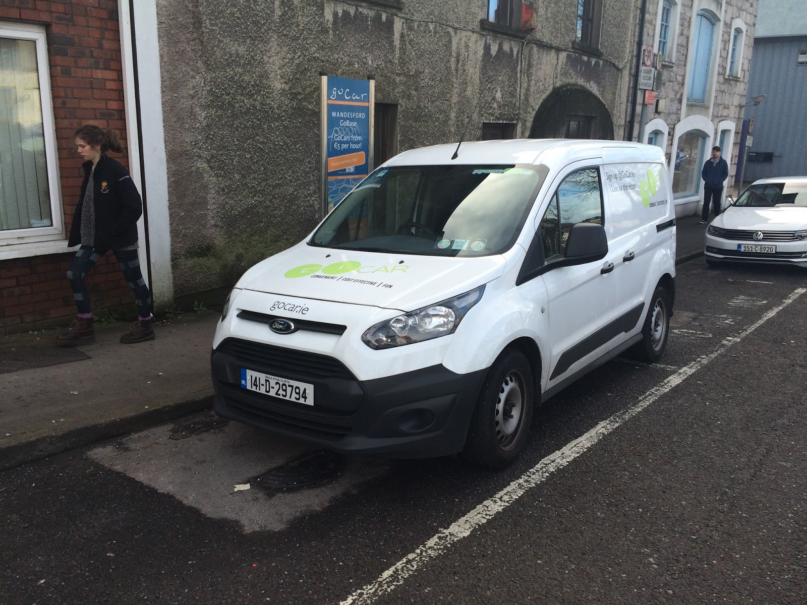
One other piece of the puzzle, which only occurred to me when I saw the ad on Facebook this morning, is car sharing. Even if you live in the city centre with all amenities within easy walking or cycling range, there are situations where you're going to need a car. Whether it's getting stuff from a store that is lightyears away from the next bus stop, or transporting something that is bulky as hell, like, say... a washing machine, these situations can arise, even if they're few and far in between. Keeping a car for situations like these is pretty uneconomical, and while regular car rental companies like Hertz, Avis, you name it, are out there, they just aren't economical for short duration rentals. That's where schemes like GoCar come in. Simply said, they take the bikesharing principle from the likes of Coca Cola Zero Bikes and adapt it for car use. The vehicles are available at certain stations throughout the city, unfortunately, Cork is currently only served by 3 stations. Expanding this network to cover major transit hubs and points of interest will be paramount to increase adoption of the system.
 |
| Just like Bike sharing, only with cars. Systems like GoCar are vital to ensure cities keep moving! |
 |
| If only the sign indicating the station was in as pristine a condition as the car itself. |
That last point I mentioned will almost certainly prove to be very costly. However, not all possible solutions will have to be expensive. Indeed, some may be as easy as combining the existing bus network map of Cork with the Cork Commuter Rail network map and the map of the Leap Card zones in Cork, all into one handy map. That would make Cork much easier to navigate in a heartbeat, especially when you combine it all in a single web site, instead of spreading out over several domains. This brings me to my next big peeve with public transit in Cork: branding. Which route is a suburban route, which one is an inner-city route, which is a long-distance route? All that may be easy to get for locals, but any foreigner will be confused by the possible variations. Combining all suburban and urban routes, as well as the rail services under a single brand would make it clearly obvious which buses you can use with your ticket.
 |
| City service? Suburban service? Long distance service? Buses like this have been used on all these types of services, so a clear optical distinction is needed. |
 |
| In addition, city services should not have stops spread out over several hundred meters, b ut rather grouped together here at Parnell Place to ensure that transfers are possible and hassle free. |
 |
| Long distance services should generally be banished to the rear, or even to a new dedicated bus terminal. |
What definitely needs to be reworked is the bus stops. While I admit that not every stop needs a shelter, any bus stop should first of all stand out clearly, and should have all necessary informations a potential passenger needs. That means that the routes serving the stop need to be prominently displayed, as do their schedules. Stops that serve high profile facilities, as well as those served by multiple lines, should also be equipped with real time departure displays, to keep passengers informed about the next services. Oh, and forget those stop codes, use regular names, they are far easier to remember.
 |
| Bus Stops with shelters that are clearly visible should be far more widespread. |
 |
| As should real time information displays, as seen at the rear of this bus stop on Grand Parade. |
Finally, the use of Leap Cards needs to be increased, as this system is much easier to handle, and also safer, especially for bus drivers, as they have to carry less change. The best way to go about this is of course to increase the number of services that Leap Cars can be used on. In addition marketing needs to be stepped up again as well, TV ads, mailings, you name it. Leap Card is by its very nature a flexible system, as the NFC chip can handle a multitude of functions. It is for example possible to integrate the cards of annual subscribers of Coca Cola Zero Bikes into Leap Cards, and that is actually being planned. Increasing the usefulness of Leap Card will ultimately make the card more attractive, and increase its usage.
So, all in all, while there is a lot that could be improved with regards to the transport situation in Cork, a number of pieces of the solution are already in place. All that needs to be done is to take all these pieces and link them together to form a coherent network. Once that is done, getting around Cork will be a lot easier than it is at the moment, which can only be a good thing!
Oh, and one more thing: LUAS or similar systems will not be viable in Cork, so don't even mention it. The geography, the structure of the urban area, all that makes the introduction of such a system extremely complex and expensive, with negligible benefits. Concentrate on the less glamorous and more practical options out there!


Comments
Post a Comment