It is one of those places that you wonder whether they ever existed. A place lodged in the back of your memory, that you visited so far back that you have to ask whether you were ever really there. We all know such places. Places that we visited as kids, places that seemed beyond belief then, and seem almost unreal now.
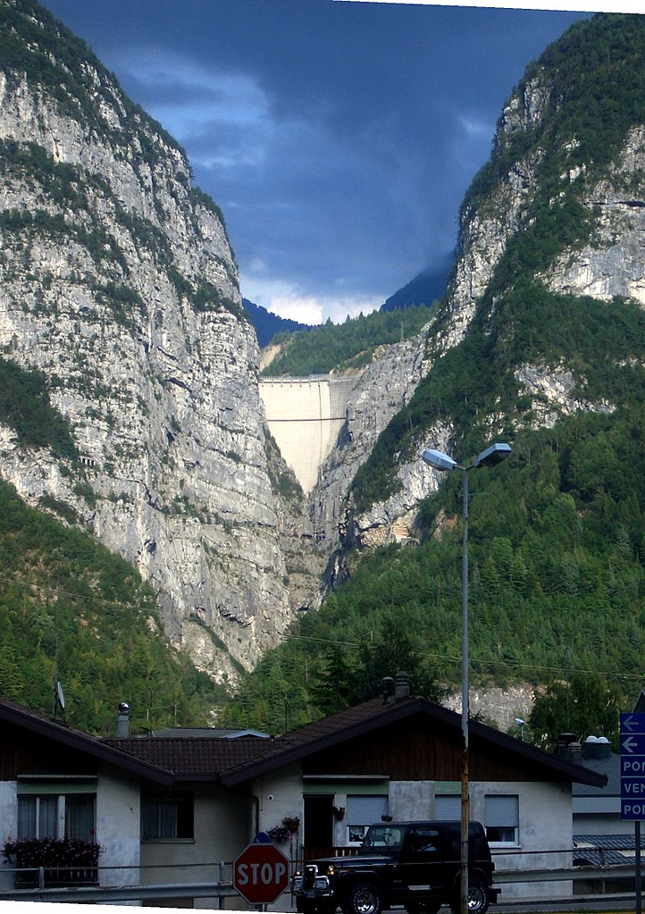 |
| The Vajont Dam, seen from Longarone |
For me, one of these places is a narrow valley in the Italian Alps. It lies in a beautiful area that has remained relatively untouched by tourism, near a village named Longarone. If you drive through Longarone, you may see a glimpse of a large concrete structure wedged between the steep slopes of a rugged alpine valley. This is the Vajont dam, that special place I was talking about. From down there, it looks like any number of dams of this type in the alps. Now follow the SR251 road from Longarone onwards. The road will snake along the side of Piave Valley, with impressive view of the valley and the town below before disappearing in a series of tunnels. Occasionally, you will come to a gallery providing a glimpse of the narrow canyon the road is built along before the road passes the dam at its crown, some 262 meters above the floor of the valley below. It is only once you exit the tunnel that the Vajont dam reveals its gruesome secret. Where a dammed up lake should be, your eye falls upon literally mountains of rock, gravel and sand. The steeply sloping back face of the dam is exposed almost all the way down. Even though the mounds of gravel in the lake bed are partially overgrown with grass, shrubs and trees, it is obvious that the area was devastated by a violent event. The Vajont gorge is the scene of one of the great forgotten disasters of Europe.
Like all great catastrophes, the groundwork of the cataclysmic rockslide of 1963 was made of the best intentions. The North of Italy had seen rampant industrialization for decades. The industrial centers on the edge of the alps had an ever increasing demand for electricity. The narrow gorge of the Vajont river near Longarone was long seen as the ideal spot for a hydroelectric dam, with a narrow gorge opening up into a relatively wide basin behind making for a decent sized reservoir. The site had been earmarked for a dam since the 1920s. However, the turmoils of World War II prevented the project from being authorized until 1943. The end of the Fascist dictatorship in Italy, and the post-war chaos in Europe further delayed the project.
It was not until the 1950s that the energy company SADE started buying land near the hamlets of Erto and Casso. Local opposition was apparently stiff and had to be overcome by police. Construction of the dam started in 1957, and it was essentially complete in October 1959. The dam itself was an impressive structure, an elegant arch dam with a height of 262 meters, but only between 27 and 3 meters thick, it drew its strength purely from its crescent shape. At the time of its construction, it was the largest dam of its kind, a title it would retain until 1971.
Earlier that year, engineers working on a road on nearby Monte Toc, which would make up the southern bank of the new Lago del Vajont had discovered multiple fractures within the mountain, including evidence of a cataclysmic landslide in paleolithic times. The entire mountain was dangerously unstable. These findings were forwarded to SADE, who ignored them and continued work on the dam. A number of small landslides during constructions caused the southern wall of the gorge to be stabilised with concrete injections into the rock. No one suspected that these landslides were mere symptoms of a bigger problem.
In 1960, SADE received the permission to begin filling the basin. By November 1960, the water level had reached 190 meters. Then, on November 4th 1960, a massive landslide of 800.000 cubic meters crashed into the lake, thankfully not causing any damage. It was a harbinger of things to come. Operating company SADE finally recognized the issue, but its only reaction was to build a number of galleries in the side of Monte Toc, to ensure that the dam could continue to operate if the basin was split in two parts by further landslides. The work was completed in October 1961 and SADE began refilling the basin. By April 1962, the water level had reached 215 meters, triggering a series of earthquakes measuring as a 5 on the Mercalli Earthquake scale, generally comparable to a magnitude 4 quake on the Richter scale. These quakes were clearly felt and registered in the hamlets of Erto of Casso. The operating company downplayed the importance of these quakes, and received authorization to increase the water level to its maximum, just a few meters below 262 meters.
However, the 1960 landslide had worried SADE enough to commission a series of experiments at the university of Padua. A 40 million cubic meter landslide was simulated by releasing a load of gravel into a scaled down model of the reservoir. The results indicated that the crest of the dam could be overtopped by up to twenty meters if the basin was fully flooded. A decision was made to keep the water level 25 meters below the crest of the dam at all times. However, this decision was quickly ignored by SADE engineers, as they believed they could control the speed of any landslide by changing the water level ad hoc.
In the spring of 1963, operation of the Vajont dam was transferred from SADE to the new state owned energy company ENEL. The summer of 1963 turned out to be one of constant anxiety for the citizens of Erto & Casso, as well as for those working the sides of the mountains. The lake was almost completely filled throughout the summer, and a nearly constant stream of small landslides and earthquakes, as well a loud noises emanating from inside Monte Toc kept everyone on edge.
Things really heated up on September 14th, 1963. The entire northern flank moved by about twenty centimeters. Ten days later, ENEL management gave the okay to lower the water level in the lake to 240 meters. It was too little too late. In early October, the side of Monte Toc shifted by one meter in a single day. A land slide was unavoidable. Still, no warning was given to the communities in the Piave Valley below, no evacuation was ordered.
On October 9th, things came to a head. ENEL Engineers operating the dam saw trees topple over and rocks crash into the lake at the predicted side of the landslide. The engineers knew that there was nothing else they could do, so, with the lake being at a safe level, they decided to to out onto the crest of the dam and watch the show. It was the last decision they made.
At 10:39 PM, the entire northern slope of Monte Toc broke off and crashed into the lake. Both the volume and the speed of the landslide were beyond any imagination, and also way beyond the scope of the lab experiments in Padua. An incredible mass of rock, over 270 million cubic meters, three kilometers wide, crashed into the lake at over 100 kilometers per hour. Almost all the water of the Lago del Vajont was forced out of the lake. Waves of incredible size and ferocity raced up the north shore of the lake and up the valley. Erto and Casso escaped total annihilation by mere meters, as a wall of water moved up the Vajont valley, destroying everything in its path.
 |
| The morning after. The size of the event only really becomes apparent when you consider that the dam is the height of the skyscrapers in the London docklands. |
The worst was yet to come. While most of the water had been forced up the valley, an unbelievable 26 million cubic meters of water were trapped between the landslide and the dam wall. It was forced upwards, creating a 250 meter high wave that raced over the crest of the dam, taking the first meter or so of concrete with it, including the engineers gathered there. Peaking more than four hundred meters above the floor of the Piave Valley, the wave than crashed down into the confines of the Vajont gorge before hitting the unsuspecting town of Longarone. The inhabitants never had a chance. The wave wiped out the entire town, leaving only the tower of the church standing. Neighboring villages, like Villanova or Rivalta were also wiped off the map. The water continued to thunder up and down the valley, causing destruction and death on a scale that not even the war had brought to this region.
 |
| View of Longarone after the disaster. Pretty much the entire town is either washed away or buried under the mud. |
When the dust settled, the true horror of what had happened began to show through. Entire villages had been destroyed. The Piave Valley around Longarone, or what was left of it, was uninhabitable and unrecognizable. From a beautiful alpine valley, it had been turned into a wasteland, a vast, muddy floodplain with a 60 by 80 meter crater marking the spot where the wave had hit. Any survivor could easily bee forgiven if he had thought that the end of the world had come. For many families, it was just that.
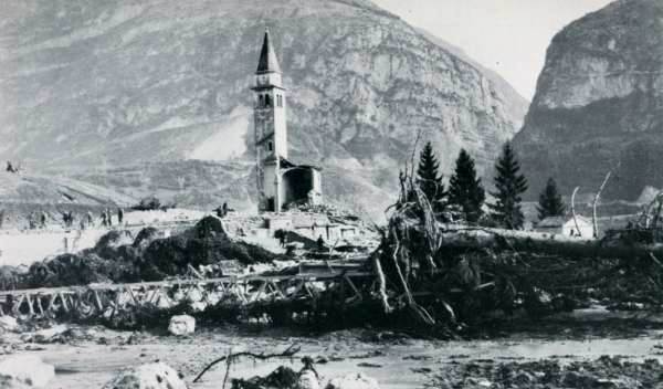 |
| The only surviving structure in Longarone was the bell tower of the church. |
The exact number of victims could never be determined, but it is safe to say that anywhere between 1900 and 2500 people lost their lives on that fateful evening. 350 families were wiped out. Rescues found depressingly few survivors.
The aftermath of the disaster turned into a disgraceful political mess, with both of the major political parties in Italy at the time using the event to demonize the other. The judicial aftermath was caught up in the crossfire and used for political mud-slinging as well. I will not venture into the blame game here. Those who are responsible will some day face justice in one or the other way. However, the question of why is still one I want to answer, even though it may get a bit technical.
What was obvious even immediately after the disaster was both the size of the landslide, being over six times greater than expected by SADE engineers during their experiments, and double the volume of the entire Lago del Vajont, and the speed. Calculations showed that the rockslide had hit the lake at over 100 km/h, adding to the already immense force of the disaster. How did all this come about? Quite frankly the answers lie in the very structure of Monte Toc itself.
 |
| View of Monte Toc from the other side of the valley. The edge of the landslide is still clearly visible even almost 40 years later. |
Like most of the southern Alps, including the Dolomite Mountains, Monte Toc consists of multiple layers of limestone, formed at the bottom of a shallow sea between the triassic and cretaceous periods. Over the following millions of years, these layers were folded and thrusted upwards during the birth of the alps. From the peak of Monte Toc northwards, these layers slowly curve into the horizontal, exposing a series of relatively young limestones in the process, before disappearing under Monte Salta on the northern side of what is now the Vajont Valley.
One would expect a simple horizontal layering of different limestones to be a very stable formation. However, in the case of Monte Toc and Monte Salta, this isn't the case, and this is not only because the limestone layers are folded back almost 180 degrees at Monte Salta. It is the Vajont river itself that destabilized this landscape. It carved its way deep into the limestone strati, creating a gorge over two hundred meters deep in places. The gorge originally ran farther north, but evidence was uncovered of a cataclysmic landslide in paleolithic times that blocked the original canyon and forcing the Vajont to carve out another path further south. This exposed and destabilized deeper limestone layers, a situation aggravated by upward thrust from a small fault line running east-west through Monte Toc.
The rocks that made up the landslide belong to a group of limestones from the late Jurassic and early Cretaceous periods resting on a thin layer of older but structurally similar layout. The boundary between these layers would prove to be critical. They were separated by layer of clay only a few centimeters thick. But, as everyone probably knows from their private lives, a few centimeters can make all the difference.
This clay boundary was exposed to the elements both in the side walls of the gorge and in a vertical formation that would be the upper limit of the landslide. Whenever the clay got wet after persistent rain, it would act like a lubricant, causing the mountainside to destabilize and triggering smaller landslides and quakes. This caused Monte Toc to be nicknamed "the walking mountain" by the locals, because it always seemed to be in motion.
When the lake began filling up, water seeped into the porous limestone and eventually reached the clay boundary layer. which began soaking up the water. As the amount of water within the clay layer increased, so did the pressure exerted along this boundary. The hydrostatic pressure exerted by the water effectively began to work as a wedge, destabilizing the upper part of the slope that would make up the landslide. The situation was compounded by the undercutting of parts of the southern slope of the Vajont gorge, which had been eroded away by the river itself. This set the slope in motion. The resulting friction at the boundary layer created heat that in turn heated up the water trapped in the clay. However, the layer continued to hold, for a while.
Things came to a head in the fall of 1963. The lake had been at its highest level since the summer, inundating the limestone and, together with the autumn rains, further soaking the clay. This, in turn increased the hydrostatic pressure along the layer, causing more movement, which caused more friction and more heat. Then, when the temperature in the boundary reached 36°C, the clay started rejecting the water it had absorbed. In effect, this created a film of water between the clay and the limestone layers above. Due to the immense pressure exerted by the water, the limestone layers basically began to float, and moved down the side of the mountain effectively without any friction, causing the immense speed of the landslide.
It was, in many aspects, the perfect storm. Even though the instability of Monte Toc had been known to SADE engineers since 1959, the fissures and layers that caused the cataclysmic event did not come to light until well after the fact.
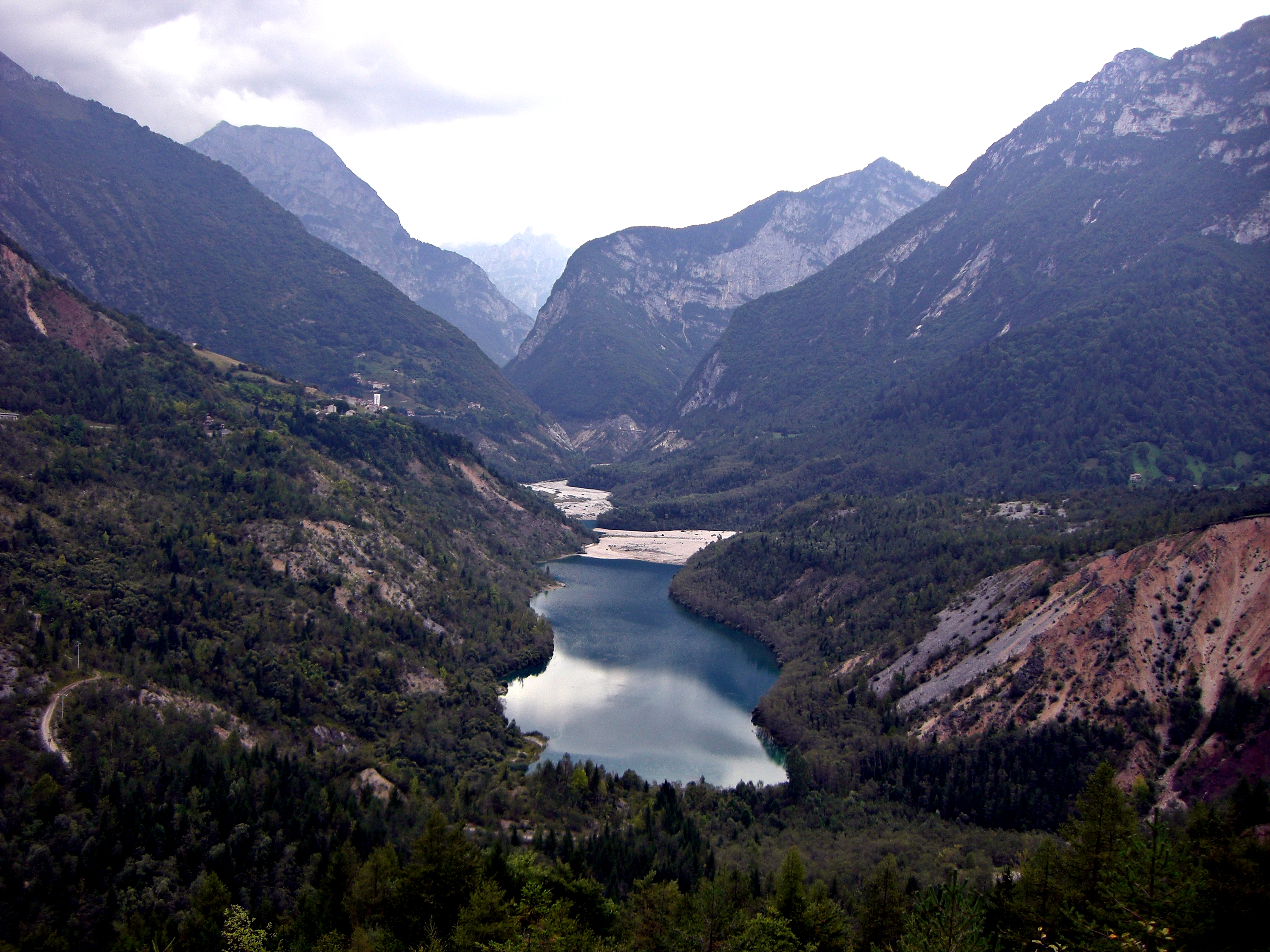 |
| View of what is left of the Lago del Vajont. The image was taken from the top of the landslide. The water level should be somewhere near the village of Erto, seen slightly to the left of the image center. |
Despite the immense amounts of rock and gravel that filled up the Vajont gorge, the lake, Lago del Vajont still exists. It is however just a mere shadow of its former size, its water level well below that of the original lake. much of the lakebed has been buried underneath the masses of debris, creating a surreal landscape unlike anything that I have ever seen. In the time since the disaster, a tunnel was excavated through the landslide to ensure proper drainage for the lake, and to prevent the water from forcing its way through the loose sediments of the disaster, and potentially causing a repeat of the 1963 disaster.
 |
| Even 40 years after the disaster, the Vajont dam still stands. I survived virtually undamaged. |
The Vajont Dam itself was the product of a time when it was widely believed that technology could overcome all obstacles. It was supposed to be a masterpiece of engineering, a shining example of what was possible with technology. And, to be honest, it was, and still is a masterpiece. During those horrible minutes of October 9th, 1963, the dam withstood pressures and vibrations that were more than eight times stronger than the maximum stress the structure was supposed to take. Even today, it towers above Longarone and the Piave valley, standing tall as a memorial to the victims of that fateful evening, and a warning to human engineers that, in the end, the forces of nature will always overcome human ambition.
Comments
Post a Comment